Slaughter Beach: The Jewel of the Delaware Bay?
Some call Slaughter Beach the jewel of the Delaware Bay because of its beautiful setting. While we’ve enjoyed several other beaches along the Delaware Bay, this is indeed one of widest and longest, with a good two miles of beach along the bay. It's great for beachcombing and sunbathing, but there are a lot of pebbles, so it’s not great for wading, swimming or walking barefoot.
 |
| Slaughter Beach looking south |
There are several theories on why Slaughter Beach got its gruesome name. One is that the first postmaster here was named Slaughter. Another is that horseshoe crabs that come here to spawn every spring are often flipped over by waves and (unless flipped back by a volunteer) die, hence the “slaughter” of the horseshoe crabs. The most gruesome story is that early European settlers slaughtered local native Americans. [UPDATE 8/15/2021: I've learned yet another theory! In a letter to Delaware Online, Barbara Slavin, Ocean View Historical Society, says the name comes from the old English word Slohtre, meaning muddy place, as in The Slaughters in the Cotswolds in England.]
Before people had cars, Slaughter Beach was a summer resort for Milford residents, with hotels, restaurants, a boardwalk and dance hall. Once people could drive to oceanfront resorts like Rehoboth Beach, Slaughter Beach became a sleepy fishing village. Today it’s a long strip of bayfront homes used by people looking for a quieter holiday than at Rehoboth, Dewey, or Bethany Beaches.
 |
| Slaughter Beach looking north |
Slaughter Beach has a large parking lot across Bay Street from the firehouse. Behind the firehouse is a pavilion with public restrooms—true public restrooms, not portapotties!!!—open April through October. Visitors are asked to stay off dunes, leash their dogs, and clean up after them.
 |
| Lexie is ready to explore the Slaughter Beach pavilion behind the firehouse |
Slaughter Beach is one of several Bayshore towns that are horseshoe crab sanctuaries. Terrapins also come ashore here. If you see horseshoe crabs flipped over, turn them upright as shown in this video. If you see terrapins crossing Bay Street, help them move in the right direction.
 |
| Wayfinding sign on horseshoe crabs near the pavilion |
In the middle of Slaughter Beach, on the inland side of Bay Street, is Marvel Salt Marsh Scenic Overlook & Boardwalk, sponsored by Abbott’s Mill Nature Center outside Milford. The short boardwalk loops through the salt marsh.
 |
| Part of Marvel Salt Marsh's boardwalk |
There are a number of wayfinding signs and kiosks to help learn about the salt march and what lives there.
 |
| Kiosk at the entrance to Marvel Salt Marsh |
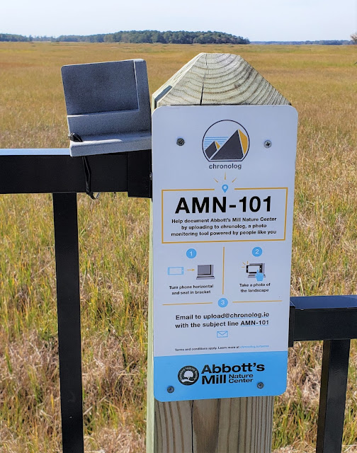
Visitors are encouraged to share photos with Abbott’s Mill.
 |
| Tool to take photos at Marvel Salt Marsh |
Just outside Slaughter Beach, along Cedar Beach Road, there are three interesting sights.
First you’ll cross Cedar Creek Bridge, a historic, picturesque drawbridge crossing Cedar Creek Canal.
 |
| Cedar Creek Bridge over Cedar Creek Canal |
Next, turn right on Lighthouse Road and follow it until it deadends at Dupont Nature Center at Mispillion River Harbor. The Center has interactive exhibits and video cameras to view wildlife along the shoreline.
 |
| Dupont Nature Center at Mispillion River Harbor |
The Center was closed when we visited (it’s open March through September), but the deck is open daily from dawn to dusk. It has great views of the Mispillion River Harbor and remnants of the old fishing industry here.
 |
| View from Dupont Nature Center, looking north toward Mispillion River |
Lighthouse Road is sometimes flooded during high tides, so check the tide chart for the Mispillion River Entrance before you visit Dupont Nature Center.
Back on Cedar Beach Road, a few hundred feet west of Lighthouse Road, you can catch a glimpse of one of the bunkers of Fort Saulsbury on the south side of the road.
 |
| One of Fort Saulsbury's batteries |
Fort Saulsbury was built in the early 20th century with two batteries, each with a bunker and two gun pads. One of its watch towers is still at Big Stone Beach. Fort Saulsbury made Fort Dupont further upstream obsolete for coastal defense. Fort Dupont was built along the Delaware River when guns had a limited range. Fort Saulsbury was built when guns had a long enough range to protect the wider Delaware Bay south of Fort Dupont. During World War II, new technologies let the Delaware Bay be protected by even longer range missiles further south as well as by air. These developments made Fort Saulsbury's guns obsolete and, like Fort Dupont, Fort Saulsbury became a prisoner of war camp. After the war, the fort was deactivated and the property sold. Today the batteries are all that remain. They are on private property, so please only view what you can from the road.
A historical marker is a bit farther west on Cedar Beach Road.
In winter, when the leaves are off the trees, from the marker you can catch a glimpse of the second battery through the trees.
 |
| A second battery at Fort Saulsbury visible through the trees |
UPDATE 7/2022:
- ‘It’s a different vibe, for sure’: Slaughter Beach in Delaware a destination for ecotourism enthusiasts in the Baltimore Sun
- Slaughter Beach Wildlife Attracts Nature Loving Beachgoers by the Delaware Nature Society
- America’s Best Kept Secret Is Hiding Right Here In Delaware And It’s Calling Your Name by Only in Your State


Did you only visit Slaughter Beach at low tide like the pictures suggest? At high tide, many, if not most, of the rocks are under water and people enjoy swimming and boating.
ReplyDeleteYes, I did visit only at low tide! We'll have to go back sometime at high tide.
Delete