Port Penn: A Well-Preserved Early American River Town
We spent a lovely morning this week exploring the fascinating little town of Port Penn.
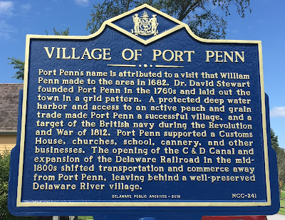
Port Penn is named for (wait for it) William Penn, who stopped here briefly for fresh water on his way to landing in New Castle in 1682. It was an informal village until the mid-1700s, when David Stewart envisioned Port Penn as a major port rivaling Philadelphia, shipping local agricultural products. He laid out streets and lots in the grid pattern often seen in large cities.
While Port Penn was busy through the mid-1800s, it never achieved Stewart’s vision. Competition from the Chesapeake & Delaware Canal and railroads put an end to its development. Today the town is little more than about two square blocks, with virtually no buildings built in the last hundred years and 80% built before 1868. While many of the buildings have been altered over the years and covered with modern siding, it’s easy to envision how the town looked 150 years ago. You'll see a town of working-class people who made their living off the water: fishing, trapping, hunting, and shipping.
 |
| "The Waterman" statue outside Port Penn Interpretive Center |
Most of the houses are what some architectural historians call folk or vernacular houses: plain, simple, everyday houses, built to provide homes for working-class people but not to follow the architectural style of the moment. You won’t find here many of the architectural details that define, say, the Greek Revival buildings in Delaware City. In fact, comparing the finely detailed houses in Delaware City with the simple, older houses in Port Penn shows vividly how Delaware City overtook Port Penn and prospered at Port Penn’s expense.
Today the Port Penn community is investing in honoring its history. A schoolhouse built in 1856 or 1886 (sources give varying dates) is now an Interpretive Center with museum displays and friendly staff.
 |
| Port Penn Interpretive Center in a 19th century schoolhouse |
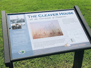
Visitors can learn about Port Penn’s history and key buildings through a self-guided tour handout at the Interpretive Center, some wayfinding signs around town, and small plaques in front of some of the homes.
 |
| Wayfinding sign for John Cleaver House, also known as Linden Hall |
 |
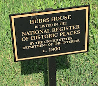
| One of the many small building plaques you'll see around Port Penn |
Port Penn has also invested in honoring and protecting its environment. Across Liberty Street from the Interpretive Center is the Port Penn Wetlands Trail, a one-mile walk through the marshes of the Augustine Wildlife Area.
At the beginning of the trail is one of the floating cabins once used for fishing in the river and wetlands. There's also supposed to be a muskrat skinning shack nearby, but that was gone when we visited.
 |
| Floating fishing cabin on Port Penn Wetlands Trail |
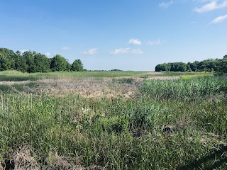
There’s a boardwalk over some wetlands before the trail turns into a grass path. The path was pretty soggy from recent rains when we visited, so we’re planning to come back and walk the trail another time when it’s drier.
 |
| Our dog Lexie enjoying the Port Penn Wetlands Trail boardwalk |
 |
| Lovely view from the Port Penn Wetlands Trail boardwalk |
A block away from the Interpretive Center is the Presbyterian Church on the southwest corner of Market and Stewart Streets. This was built as a frame building in 1834, then rebuilt with brick in 1856.
 |
| Port Penn Presbyterian Church |
Behind the Presbyterian Church on Stewart Street is one of Port Penn’s gems: Stewart House, built by David Stewart, the founder of Port Penn, between 1740 and 1755 (sources give varying dates). Stewart built this as a farmhouse before he laid out the town, which is why the house sits at an angle to the street. You can tell from the size and construction quality of the house that he was a wealthy farmer.
 |
| Stewart House |
Across the street from Stewart House is a blue house known variously as Cleaver-Hall House, Hall House, or Wild-Cleaver House. It was built around 1792 and is considered the second oldest structure in Port Penn after Stewart House.
 |
| Cleaver-Hall House, also known as Hall House or Wild-Cleaver House |
Next door, at the southeast corner of Market and Stewart Streets, is the white Dunlap-Bender House. The original section, which I think is the section in the middle of this photo, was built in the 1790s shortly after the Cleaver-Hall House. The other sections of the house were added starting in the mid-1800s.
 |
| Dunlap-Bender House |
On Stewart Street north of Market Street is St. Daniels United Methodist Episcopal Church, built in 1844. I love the simple design—it’s a great example of Port Penn’s unpretentious architecture.
 |
| St. Daniels United Methodist Episcopal Church |
On the northeast corner of Market and Congress Streets is another Port Penn gem: Linden Hall, also known as Joseph Cleaver House. It was built between 1814 and 1845 (sources give varying dates) in Federal style. When it was built, Cleaver was the most important man in Port Penn, owning much of the town’s property plus a shipping business. If you look carefully at the wall on the left side of the photo, you can see that the building is actually a duplex. Cleaver and his family lived on the left half, while the right half was offices and storage for his businesses. The large doors and windows let him keep an eye on comings and goings from the wharf.
 |
| Linden Hall, also known as Joseph Cleaver House |
Wings were added later to the rear and north side of Linden Hall, and it became a hotel. The wings deteriorated and are now gone, but it’s easy to see where they were once attached to the building.
 |
| North end of Linden Hall |
 |
| Linden Hall rear |
The Port Penn Historical Society has a good article on Linden Hall in one of its newsletters.
But where was the wharf that was once Port Penn’s hub? It was at the east end of Market Street, an area now overgrown with trees. Beyond the trees, there are now several hundred feet of marshes between Market Street and the river.
 |
| East end of Market Street, where there was once a wharf on the Delaware River |
North of Linden Hall is the Commandant’s or Commander’s House, a Colonial Revival house built on Reedy Island in the Delaware River around 1930. Between the 1890s and World War II, Reedy Island was a quarantine station for ships heading to Philadelphia, inspecting ships, sailors, and immigrants for disease. It had a disinfecting station, small hospital, and housing for staff. One of my grandmothers immigrated to Philadelphia early in the 20th century, so it’s very likely she was one of the passengers who stopped there.
After the quarantine station closed down, three buildings including the Commandant’s House were floated to Port Penn on barges in the 1950s. What was originally the front of this house now faces Linden Hall.
 |
| Commandant's or Commodore's House |
The other two houses floated to Port Penn from Reedy Island are a couple of blocks south on Congress Street, on the west side.
 |
| One of the other houses floated to Port Penn from Reedy Island |
This web page is a great article on Reedy Island with old photographs. It has information and old photos on Commandant's House and the other two houses floated to Port Penn.
North of the Commandant’s House, on the west side of Congress Street, is Hubbs House, an adorable house built from a mail order kit around 1900-1915. This house has a lot more architectural details than most of the houses in Port Penn, a sign that the family who built it was relatively well off.
 |
| Hubbs House |
As we left Port Penn, we checked out one last historic house: Dilworth House, about a mile and a half west of the Port Penn Interpretive Center on the north side of West Market Street. If you look closely at the front, you can see that it was built in two sections, with a seam running down the middle. The west (left) side of this impressive farmhouse was probably built in the late 1600s, which would make it one of the oldest houses in Delaware. The east (right) side was added in the early 1700s, and the frame addition in the back in the late 1800s. I was really intrigued by the brickwork, which includes two different colors of bricks, arched windows, and interesting lines above the porch roof and along the ground.
As you plan your visit to Port Penn, keep in mind that it can be hard to identify many specific buildings. Many don’t yet have plaques, most aren’t yet labeled on Google Maps, and the self-guided tour’s map isn’t drawn to scale.
Another challenge is that historic houses are often identified in online sources by names rather than street addresses, and sometimes there are multiple names. While historic houses typically named after the first person who owned them, sometimes a more significant family lived in the house later, and the house may be known by either or both names.
 |
| This plaque is for a house also known as Cleaver-Hall House and Hall House. |
And yet another complication is that some houses in Port Penn have similar names because they were owned by different members of the same family. There are multiple Stewart and Cleaver houses, for example.
 |
| This Cleaver House is a block away from the Wild-Cleaver/Cleaver-Hall/Hall House. |
My suggestion is to focus on the overall town rather than specific buildings. This is more a place to step back in time than to seek out particular buildings. Wander around Port Penn, checking out the wayfinding signs, plaques, and self-guided tour as you go. You'll have a relaxing and informative visit.


Comments
Post a Comment